The Cavan Leitrim Railway was formed in 1883 to connect the towns of Belturbet, Ballyconnell, Ballinamore, Mohill and Dromod.
After a public meeting in Ballinamore on September 14, 1883, it was decided to develop a Light Railway to connect the towns of Belturbet, Ballyconnell, Ballinamore, Mohill, and Dromod. A steam Tramway was also planned from Ballinamore to Drumshanbo, terminating in Boyle. This initiative aimed to meet public needs and open the Arigna and Lough Allen regions for coal and Iron deposits.
On December 3, 1883, the Cavan, Leitrim & Roscommon Light Railway and Tramway Co. Ltd. was registered. An engineer employed by the company recommended a narrow-gauge railway due to the ground conditions and landscape. However, in 1884, the Roscommon juries withdrew their guarantee for the tramway section from Arigna Ironworks to Boyle, halting those plans. The Cavan and Leitrim juries agreed to share the costs for the final section from Drumshanbo to Arigna despite the last mile lying within the Roscommon border.
When the railway commenced service from Dromod to Belturbet in October 1887, and from Ballinamore to Arigna in May 1888, livestock became its primary revenue source.
The extension to the coalmines beyond Arigna village took another 32 years, becoming fully operational in 1920. Before this, local farmers transported coal to the station during their spare time.
At this stage, coal had taken over as the main revenue source for the train but was competing against the roadway by the 1930s. To reduce costs, the railway company demolished several carriage sheds, but unfortunately, this reduced the condition of its stock.
In 1955, the Electricity Supply Board announced the construction of a coal-fired power station on the shores of Lough Allen. The power station was predicted to absorb the entire coal output from the Arigna mines. This proved to be the death knell for the Cavan and Leitrim Railway, eradicating its main revenue source.
The line finally closed on Tuesday, the 31st of March 1959. Without hast, the company immediately set about demolishing the railway, rails lifted and sold, and engines and carriageways either sold off or demolished. [synopsis is taken from The Cavan & Leitrim Railway, Patrick J. Flanagan 1977]
In 2017, the Ballinamore Development Company successfully secured funding to commence construction of a demonstration section of the greenway from the Scouts Den at Lahard to Killdorragh. Leitrim County Council agreed to assist with greenway project management at this stage. Leitrim County Council successfully attained funding for the continuation of the project in collaboration with Ballinamore Development Company for the construction of the greenway to Corgar.
In 2021, Leitrim County Council successfully applied for further funding from the ORIS Outdoor Recreational Infrastructure Scheme to continue the project from Corgar to the townlands of Lisgruddy, Corduff, and Drumcullion. Construction works commenced in September 2023.
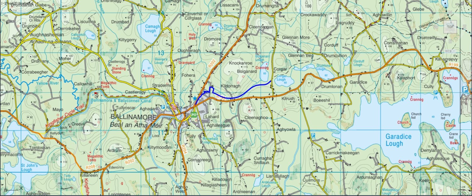
The Ballinamore to Corgar Greenway closely follows the footprint of the former Cavan and Leitrim Railway, commencing from Ballinamore station and terminating adjacent to Corgar Lough. The greenway was completed in the Autumn of 2021 and formally opened on Friday, 17th June 2022. Leitrim County Council has progressed the extension of another section of the railway from Corgar Lough to Aghawillin (formerly Garadice Station). Construction of the additional section will be completed in October 2024 and will be opened as a public amenity in the immediate future.
Consultations are ongoing, and plans are underway to extend the greenway further towards the Cavan County border, which is only 2.25 km away. This extension aims to enhance connectivity and provide more recreational opportunities for locals and visitors.
The greenway offers an excellent way to explore the beautiful landscapes of Leitrim while enjoying a piece of the region’s railway heritage, with its many extant masonry bridges and abundant wildlife as the greenway snakes along the Bolganard, Corgar, and Drumlonan.
GRADE: Easy
LENGTH OF WALK: 5.2km
TIME: Approx 2 hour
WAYMARKING: Yes
DOGS ALLOWED: Yes, on a lead
FACILITIES NEARBY: Ballinamore. Shops, pubs, cafes/restaurants and accommodation.
TRAILHEAD/STARTING POINT: At St Felim’s College, Co-ordinates ITM: 613354, 811778,
End Point Co-Ordinates, ITM: 617232, 813382.
DIRECTIONS TO THE STARTING POINT: The greenway commences adjacent to the public carpark in the centre of Ballinamore. The greenway can also be accessed off the local road L-5375-0 carpark adjacent to Bolganard and Corgar Lakes.